WILD HONG KONG
  • Home
  • Our Guided Tours
    • Hiking Tours >
      • Easier Classic HK Hikes >
        • Dragon's Back Trail
        • Victoria Peak (The Peak)
        • Lion Rock
      • Moderate Wilderness Hikes >
        • Ng Tung Chai Waterfalls
        • Sai Kung Deserted Beaches
        • Sai Kung Geopark Coastal Hike
      • Challenging Hikes >
        • Ma On Shan Climb
        • Wong Lung Hang Stream Trek
        • Lantau Peak Sunrise Climb
    • Cycling Tours >
      • Wetlands Cycle
      • Tolo Harbour Cycle
      • Plover Cove Cycle and Hike
      • Tai Lam Mountain Biking
    • Kayaking & SUP Tours >
      • Geopark Kayaking ​(Beginner / Intermediate Level)
      • Geopark Kayaking Sea Arches (Advanced Level)
      • Hoi Ha Kayaking
      • Sai Kung SUP
    • Events, Programmes & Team Building
    • School Holiday Adventure Programmes >
      • Kayaking - 5 Day Programme
      • Mixed Activities - 5 Day Programme
      • Hiking & Stream Trekking - 5 Day Programme
    • Gift Vouchers
  • Book A Tour
  • About us
  • Merchandise
    • Clothing
    • Hats
    • Accessories
  • More
    • Blog
    • Media
    • Weather Forecast
    • General Requirements
    • Terms and Conditions
    • FAQs
    • Contact Us
  • 🌐
    • 中文
    • English
    • Français

TSING YI –The isle of bridges 

3/5/2016

2 Comments

 
​IN THE MAY ARTICLE OF OUR MONTHLY COLUMN IN SAI KUNG/SOUTHSIDE/EXPAT PARENTS MAGAZINES; WE EXPLORE THE ISLAND OF TSING YI AND EXPOSE SOME EXCITING HIKING LOCATIONS THAT ARE LARGELY UNKNOWN IN HK

Once remote and untouched, the island of Tsing Yi is anything but nowadays. Located to the northwest of Hong Kong Island and south of Tsuen Wan, the island has become a major transport hub and commuter base. Many of us pass through on a regular basis, but most overlook the island as a destination due to its urban appearance. A hotspot for infrastructure, the creations that mankind has erected around these parts is the stuff of civil engineering dreams! Nevertheless, for all the construction of recent decades, Tsing Yi still possesses some surprisingly secluded areas, peppered with nature walks and stunning viewpoints to accompany them.
 
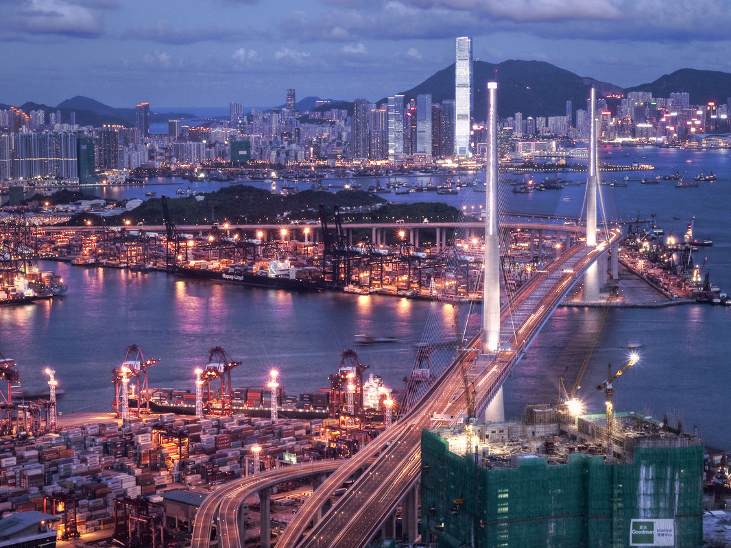
Tsing Yi's name literally means "green clothes", but the island actually got its name from a type of fish once abundant in nearby waters. Before the Tsing Yi South Bridge was built in 1974, the old Tsing Yi pier was the only link between the island and the outside world. Fast-forward to today, the island is now home to about 200,000 people and is connected by eight bridges all around the island. This includes the Tsing Yi and Stonecutters Bridges, respectively the largest and third largest of their kinds in the world!
Tsing Yi Hike
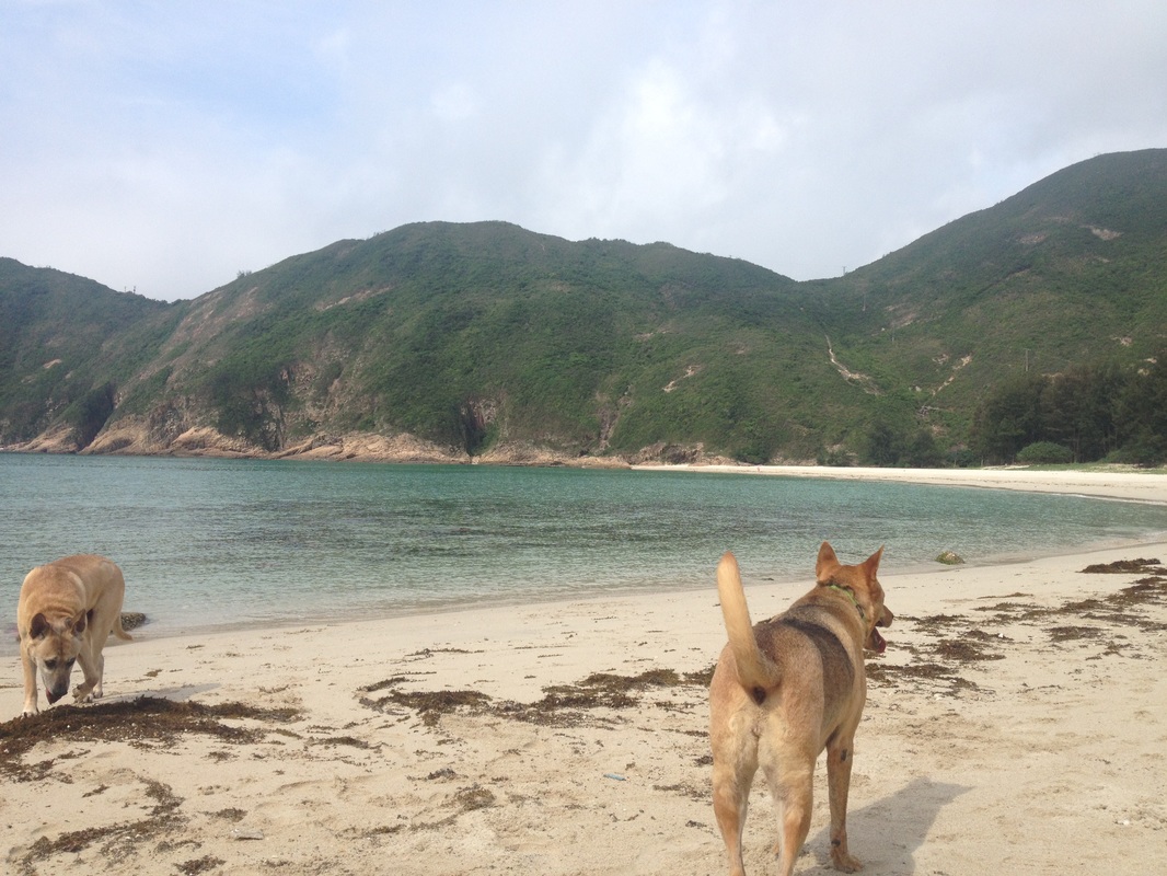
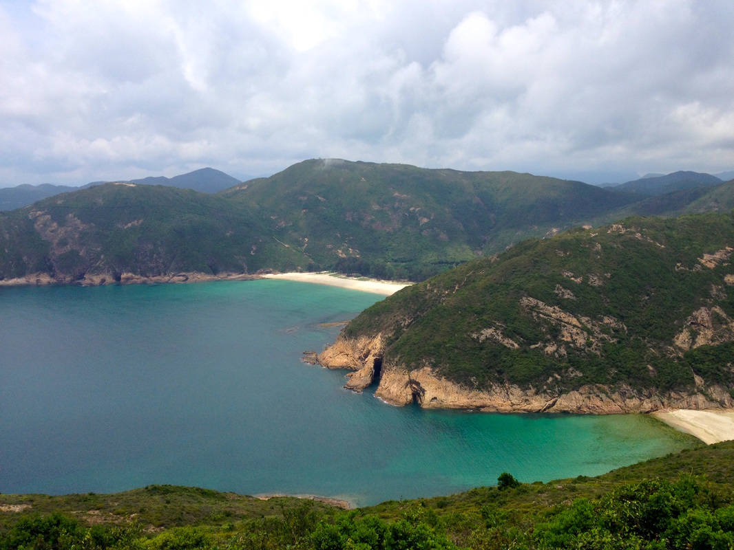
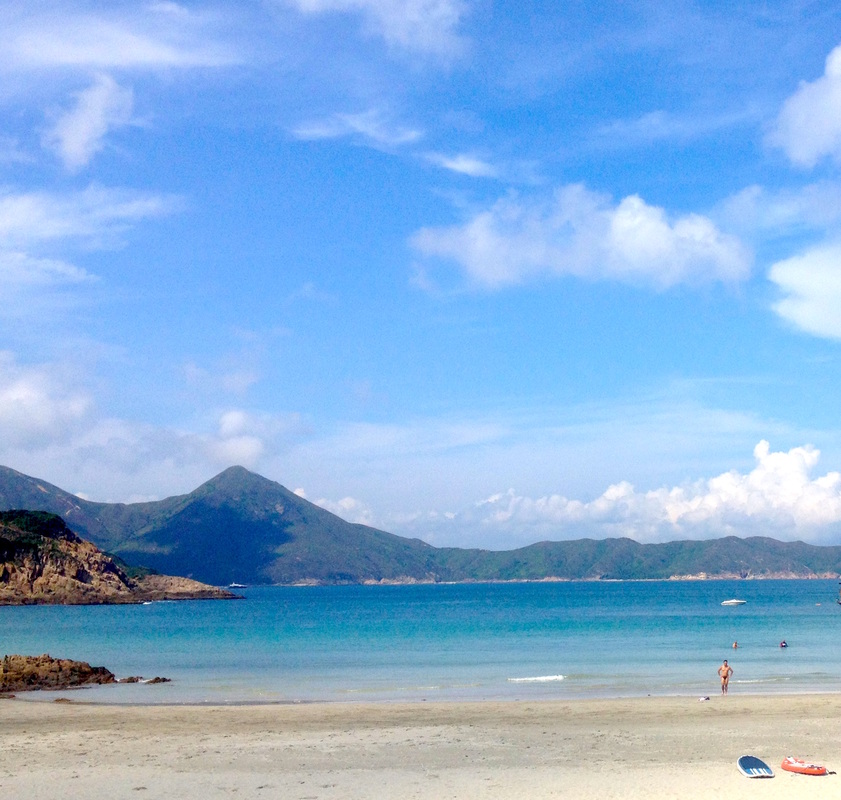
There are a couple of fantastic short to mid length walks around the rural parts of the Island, offering a range of experiences from an easy going family stroll, to challenging assents. Either way, you’re guaranteed a peaceful retreat from city life, epic bridge vistas and fresh air.
 Option 1, Tsing Yi Nature Trail (Easier)
Covering the western hills of the island, the Tsing Yi Nature Trail offers an easy going, family friendly option. The network of paved paths is well mapped and signposted throughout. Peppered with exercise areas, pavilions and viewpoints, it suits those who desire an accessible and flexible route. From end to end, the trail is approximately 3km in length and is done within an hour if you stay on the move. I recommend taking your time to follow some of the detours along the way and admire the stunning views over the Tsing Ma Bridge and out to Lantau. The most convenient way to reach the trailhead via public transport is to hop off the MTR at Tsing Yi Station and ride the 248M bus to the last stop, from there 10 minute stroll up Liu To Road will get you to the start of the trail network. Alternatively, you can walk straight to the trails from the MTR; this will take around half an hour.

Tsing Yi Hike
Option 2, Sam Chi Heung (Harder)
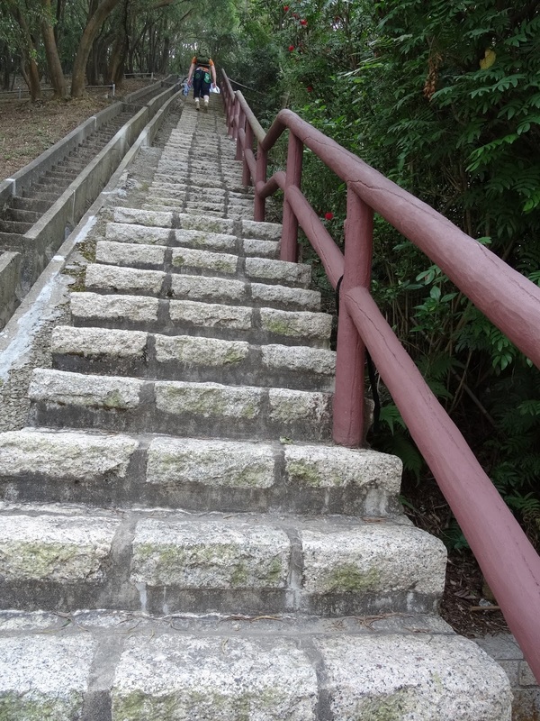
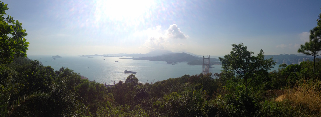
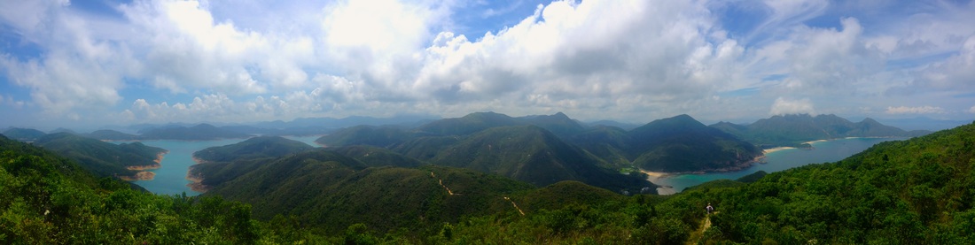
For the more adventurous folk out there, climbing up Sam Chi Heung is an awesome option. The route is direct and prominent, gaining a few hundred meters of elevation above all the surrounding areas. The three summits of Sam Chi Heung are not as heavily forested as the Tsing Yi Nature Trail, thus providing uninhibited panoramas over Tseun Wan, Kowloon and HK Island. But undoubtedly, the main attraction of climbing Sam Chi Heung is the unique vantage point it provides to look over the Stonecutters Bridge and Hong Kong Port. Find the trailhead located beside Cheung Ching Bus Terminus and follow it past some football/soccer pitches. You will start to ascend and not before long, reach a large burial area scattered across the hillsides. Once atop the first peak, it’s worth continuing along the trail until you reach the third peak, as this is where the best views are to be had. The simplest way down is a return to Cheung Ching Bus Terminus. However, for the really adventurous folk out there, keep an eye out for ribbon marked alternate routes down.
Tsing Ma Bridge
​If you ever wish to stop and take in views of the Tsing Ma Bridge without having to go hiking, the Lantau Link Visitor Center could be worth a visit. Open every day other than Wednesday, the center can be reached by public transport via the 308M minibus from Tsing Yi MTR. Taxi and by car are also great ways to reach this location.

If you’re really enthusiastic, both walks can be done together as a day hike. What is great about all of these itineraries on offer is the ease of return to public transport and other amenities. That is the beauty of venturing out in a place such as Tsing Yi (and Hong Kong in general for that matter); after working up a sweat out and about, you can soon find respite. This accessibility is certainly one of Tsing Yi’s main draw cards, a tremendous place to visit on a whim without premeditation. But once you have arrived and got under the skin of this dramatic isle, the rugged hillsides and ‘bridgetastic’ vistas will sell themselves. A trip through Tsing Yi will never feel the same, after coming to truly appreciate this underrated area of Hong Kong.
2 Comments

Tung Lung Chau -the wild column

7/2/2016

0 Comments

 
IN THE FEBRUARY ARTICLE OF OUR MONTHLY COLUMN IN SAI KUNG/SOUTHSIDE/EXPAT PARENTS MAGAZINES; WE VENTURE OUT TO THE RUGGED ISLE OF TUNG LUNG CHAU FOR A MEMORABLE ADVENTURE

Picture
​Rugged, windswept and diverse, Tung Lung Chau possesses a little bit of something for everyone. From family friendly outings and historical rekeys, to rock climbing and zip lining sessions, this craggy outcrop has all the tricks to keep you more than entertained for the day! Easily reached, it makes for a convenient full or half day trip away from the city.
Picture
To reach the island, take a ride on the ferry from Sam Ka Tsuen Public Pier in Yau Tong (5 mins walking distance from Yau Tong MTR Station). Several sailings make their way to Tung Lung Chau each day until 4:30pm; visit bit.ly/TungLungChauFerry for the complete ferry schedule. Make sure to check out climatic conditions on the day before venturing onto the water. If the weather is wild, it may not make for the most pleasurable of experiences, but on a fair day the island and its surrounds are simply stunning. Departing adjacent to the picturesque Lei Yue Mun Village, the ferry then embarks across the open waters of eastern Victoria Harbour. There are brilliant views across the Clear Water Bay Peninsula to the north and to Shek O Peninsula to the south.

Half an hour on board the ferry flies by and Nam Tong ferry pier soon comes into view. Once ashore, you’re greeted by an enticing selection of route options. For those who fancy either a relaxing day out or desire to cut out the fuss and be thrust straight into the action, hang a left at Nam Tong following signs for Tung Lung Fort. A twenty minute stroll from this juncture takes one directly to the eastern side of the island. For the more intrepid traveler, a longer walk around the island may suit. There is an 8.5km route circumnavigating Tung Lung Chau that takes around 4 hours to complete and is best experienced in an anticlockwise direction. This trail is a great way to pack in all the sights of the island, including a climb to its 232m pinnacle.
No matter which of the two routes is taken, one will arrive at Tung Lung Chau’s northeastern promontory where Tung Lung Fort is located. From here folk can get hands on with the main attractions on offer. Close to the campsite lie the remains of Tung Lung Chau Fort, built between 1662 and 1722 by order of Yang Lin, Viceroy of Guangdong and Guangxi. It used to defend the island from pirates attempting to enter Victoria Harbour from the South China Sea.
 
Climbers don’t forget your chalk bag! Regarded as one of the best places in Hong Kong for rock climbing, the eastern escarpments of Lung Tung Chau offer bountiful climbing lines in a scintillating setting. There are several operators that provide climbing and zip lining sessions here, visit bit.ly/TungLungChauGuide for more information.
Picture
Be sure to catch the final boat leaving the island for return to the mainland at 5pm, unless an overnight stay is more your cup of tea. Camping in HK can be an awesome experience and Tung Lung Chau is a superb illustration of this. The campsite beside Tung Lung Fort has adequate facilities and a rugged waterfront setting to die for. Weekends and public holidays can be busy here so be wise with your timing, try not to visit on a public holiday. If you have a bit of time to kill before the next ferry departure, perhaps make a detour to see Hong Kong’s oldest and largest rock carvings, dating back over 5000 years the dragon depiction is a relic worth seeing. Alternatively, relax at one of the islands several dai pai dongs (local cafes).
 
All in all, this is a cracking little spot that all can to enjoy in different ways. Among the list of Hong Kong’s many islands, Tung Lung Chau flies under the radar and punches well above it’s weight.
0 Comments

Sai Kung Beaches- The Wild Column 

8/7/2015

0 Comments

 
THE SECOND ARTICLE OF OUR MONTHLY COLUMN IN SAI KUNG/SOUTHSIDE MAGAZINES; WE HIGHLIGHT A SOLID SUMMER HIKE OVER SAI WAN SHAN, EXPLORING THE BEST OF SAI KUNG'S BEACHES ALONG THE WAY.

"Venturing into the wilds of Sai Kung, the plethora of options open to hikers is astounding! Amongst the area’s finest beaches are Long Ke and Sai Wan. Of the many people who visit these spots, few manage get the sand of both beaches on their feet in a single visit. However it is possible!

Essentially this route is simply a segment the MacLehose Trail stage 2, however it is the optimal way to see many of the regions finest beaches in one go; from Long Ke in the south, all the way up to Tai Long Wan in the north.
Getting there can take a little time from HK Island and Kowloon, but it is a relatively hassle free trip. Having reached Sai Kung, grab a cab out to the East Dam of High Island Reservoir for around $100; tell the taxi driver to head towards Long Ke and you will know when you are at the dam because it is the end of the road. 

The drive around the azure waters of High Island Reservoir is very scenic and upon arrival at the east dam it is definitely worth having a look around before charging up the trail. The natural rock formations in the area are very special and if you have a little extra time, exploring the adjacent HK Geopark makes for a fun detour.
Long Ke
Arrival at Long Ke, the first of many stunning beaches en route
From the turning circle, depart the paved road and follow a footpath up and over the hill. Before long you will be greeted by the inviting sight of Long Ke Wan, our first beach en route. The path leads straight down to some of the whitest sands and clearest waters in all of Hong Kong. Often on weekdays, you will have this little slice of paradise all to yourself.

Soak it up before biting into the heart of this route, the hike up and over Sai Wan Shan. Working one’s way up to the 314m Summit is hard work on a summers day, however it is all worth it for what awaits on the other side. 
Canine camera crew
Long Ke
Walking Northwards looking back to Long Ke Wan
Relaxing on Sai Wan Beach
The path is very well trodden and the panoramic views from the top of the hill are so good it’s silly. Overlook upon the entire eastern Sai Kung peninsula; encircled by golden beaches, piercing peaks and rugged headlands. The contrasts between the waters of High Island Reservoir and the South China Sea are particularly easy on the eye.

Drop back down into the shady valley below, following the MacLehose Trail to Sai Wan Beach where cooling refreshments await! From that juncture one can either return up the paved footpath for 45minutes to reach the Sai Wan access road or continue onwards. The beaches to the north at Tai Long Wan are more expansive and well worth the effort to reach.
Sai Wan Shan
Panorama from the summit of Sai Wan Shan
Heading onwards, the extensive walk around the Sai Kung Peninsula to Wong Shek Pier will take quite a long time to complete and is better left to the more intrepid during the warmer months. But in the cooler months it makes for a truly jaw dropping day on the move away from civilisation. For those who don’t want to bite off more than they can chew, venture as far north from Sai Wan as you feel comfortable with, before returning to Sai Wan. From there, one can hike up to the road or take a boat back to Sai Kung. If hiking back remember to call for a taxi (+852 2729 1199) in advance, as mobile reception in the area can be fickle."


http://www.southside.hk/latest-issue/ 
0 Comments
Forward>>

    Categories

    All
    Beaches
    Boating
    Camping
    Cycling
    Generic
    Hiking
    HK 5 Trails MTB
    HK Island
    Islands
    Kayaking
    Lakes
    Lantau Island
    Lion Rock
    Mountain Biking
    Ng Tung Chai
    Rainforest
    Sai Kung
    Waterfalls
    Wildlife

    Picture

    About us

    We are one of Hong Kong's premier adventure & eco tour operators. This is our blog, documenting many of the wild places we explore and show guests.

    RSS Feed

    Archives

    September 2024
    June 2024
    May 2024
    April 2024
    December 2022
    November 2021
    October 2021
    September 2021
    June 2021
    May 2021
    March 2021
    January 2021
    December 2020
    November 2020
    October 2020
    September 2020
    June 2020
    April 2020
    March 2020
    February 2020
    October 2019
    September 2019
    August 2019
    July 2019
    May 2019
    May 2017
    April 2017
    February 2017
    January 2017
    November 2016
    October 2016
    September 2016
    August 2016
    July 2016
    June 2016
    May 2016
    April 2016
    March 2016
    February 2016
    January 2016
    December 2015
    November 2015
    October 2015
    September 2015
    August 2015
    July 2015
    June 2015

FAQs
GENERAL REQUIREMENTS
TERMS & CONDITIONS

Whatsapp / Phone +852 6025 3862  
​Contact Us 

Copyright © 2015-2025  Wild Hong Kong 
  • Home
  • Our Guided Tours
    • Hiking Tours >
      • Easier Classic HK Hikes >
        • Dragon's Back Trail
        • Victoria Peak (The Peak)
        • Lion Rock
      • Moderate Wilderness Hikes >
        • Ng Tung Chai Waterfalls
        • Sai Kung Deserted Beaches
        • Sai Kung Geopark Coastal Hike
      • Challenging Hikes >
        • Ma On Shan Climb
        • Wong Lung Hang Stream Trek
        • Lantau Peak Sunrise Climb
    • Cycling Tours >
      • Wetlands Cycle
      • Tolo Harbour Cycle
      • Plover Cove Cycle and Hike
      • Tai Lam Mountain Biking
    • Kayaking & SUP Tours >
      • Geopark Kayaking ​(Beginner / Intermediate Level)
      • Geopark Kayaking Sea Arches (Advanced Level)
      • Hoi Ha Kayaking
      • Sai Kung SUP
    • Events, Programmes & Team Building
    • School Holiday Adventure Programmes >
      • Kayaking - 5 Day Programme
      • Mixed Activities - 5 Day Programme
      • Hiking & Stream Trekking - 5 Day Programme
    • Gift Vouchers
  • Book A Tour
  • About us
  • Merchandise
    • Clothing
    • Hats
    • Accessories
  • More
    • Blog
    • Media
    • Weather Forecast
    • General Requirements
    • Terms and Conditions
    • FAQs
    • Contact Us
  • 🌐
    • 中文
    • English
    • Français